In the early 1990s, the University of Minnesota (UMN) was pioneering an early adaptation of the internet. The Raptor Center (TRC) adopted this new technology as well as the innovative method of using satellite telemetry to track the flyway paths and patterns of raptor winter migration, specifically ospreys.
To accomplish this feat, satellite transmitters needed to be attached to raptors. TRC, along with expertise of the UMN’s computer programming team, designed customized backpacks housing these transmitters for the ospreys to wear. Permitted bird bander Mark Mattell then outfitted ospreys across Minnesota, Oregon, and along the east coast from Maine to Florida.

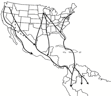
As it turns out, osprey migration is complex. Osprey females start migrating mid-August and go farther south than males who leave late September, meaning the sexes winter separately. West coast ospreys mostly migrate along the Columbia River to Baja, Mexico. Maine ospreys mostly migrate to Florida, and Florida ospreys island hop through the Caribbean—most often to Bolivia. Midwest ospreys migrate south through Florida and the Caribbean, straight over the Gulf of Mexico, or more west along the Gulf Coast and throughout South America.
With the ping of each new location data point, new questions emerged, including how to represent the data on a computer, and how to use it as a teaching tool for young students being introduced to this new technology.
With funding from the Minnesota Electronic Environmental Education Network of that time, TRC education specialists Carolyn Lane and Mike Kennedy created a 16-part online work course, called Highway to the Tropics. Students could access the website displaying the migratory data of ospreys, and teachers were provided lesson plans for students to learn about the environment and information technology at the same time.
You can view an archive of the original Highway to the Tropics website at https://z.umn.edu/TRC-Archive-HTTT.